Friday, November 30, 2012

St. Augustine....America's oldest city

 
I am sitting in a WiFi cafe in the shadow of this palm tree. It is beautiful and in the 70s today. The sun is so bright that it is hard to see the computer screen. Serenity is on a mooring ball at the city marina. It costs $20 a day! We have access to the showers, restrooms, and laundry for that fee. To go any where we launch the dink, ride about 1/2 mile, and tie her to the dingy dock which the marina provides as part of the fee. We can then walk to the historic district, or to restaurants, shops, and pretty much what ever. This is a beautiful city, and would be a great place to spend a vacation. In many ways it reminds me of Annapolis, as it seems to be more on what I refer to as a human scale...small, and not so urban, not so high tech... if that makes sense. It is such an old city, and much of the design predates the automobile, which is another reason for the smaller scale.
Shirl and I decided we are going to stay for a few days...at $20 a day to secure the boat, why not enjoy the beautiful weather in a beautiful city. One of the questions I am asked a lot is about the cost of a trip like this. I am working on a blog post about that I hope will give you a general idea.
 
 
 St. Augustine...
 
 Serenity in the mooring field...there are a lot of boats there.
 
 Bird at the marina waiting for bait fish.
 
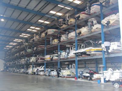
 Boat storage...Florida style
 
 Mom you were right...this pirate ship followed our dink all the way in to the marina!
 
 St. Augustine
 
 Wally World...you had to love that movie
 
 Dancing...
 

Thursday, November 29, 2012

Florida...

We are at Palm Cove Marina this morning in Jacksonville, Florida. Cross another state off of the list. We had anchored five nights in a row, so we decided to stay at a marina last night.Our last night at anchor was difficult. We anchored off of Cumberland Island and the wind was blowing at 15 to 25 mph, in the opposite direction of the incoming tide, which caused Serenity to continue to roll and turn sideways. There were several other boats anchored in the same area, and I was concerned that we would get to close. In wind with opposing current it is surprising how different boats react. The trawlers seemed the least affected, (no keel).  Anchoring is less expensive, (free) and this marina is $1.75 a foot. We needed to fill the water tank, and decided to get fuel as well. There is a fantastic restaurant here, called Marker 32. We had dinner there last night and it was great. I tried a local beer called Killer Whale and it was good as well. Today we will cruise to St. Augustine, where we plan to spend a few days, do a few boat projects, and check out the city. The weather yesterday was cool...in the low 50s, and very overcast.
We are still doing well after two months aboard. Yesterday though, it was good to get off the boat to take a nice walk, a long hot shower, and have a great dinner. We are looking forward to slowing down and relaxing...soon. Today it's back to moving south.


 Serenity approaching another double bascule bridge. I have lost count of how many bridges we have gone through.

 Nice summer home on the water.

 The Navy working on another ship.

 No problem for us!

 This island is for sale.

I have a friend who wants to retire and "live under a palm tree." Hey Greg, I know you want one further south but this one has a roof. I'll keep looking.

There are so many shrimp boats in this area.

Tuesday, November 27, 2012

The boat's draft exceeded the water's depth...

This can be a problem and was for us today. As I stated before there are some very shallow places in Georgia along the ICW. Usually if you are careful, and watch your charts, you can avoid most of these. Today however was different. The channel at statute mile marker 704... is totally silted in. The only way to get through is to disregard your chart plotter, and stay closer to the green markers...beginning with 59a. On my chart plotter there is an island that doesn't exist at 59a and it shows a shallow area that is deep enough to get through. We hit the shoal going very slow but we were unable to get off. We had to wait 2 hours for the tide to lift us off the shoal. It was soft mud...no problem, and I was able to give several other boats directions to get around the shoal. I was told that people run onto this shoal everyday. Once we were off the shoal I crossed over the island that didn't exist, and into the shallow area that was actually over ten feet deep, and continued our journey. The electronic devices that we have on Serenity are great, but they are not perfect. Sometimes you have to trust you eyes, or in today's case your instincts, and disregard the electronics. I can see where depending on them too much can limit what you learn to do yourself...not a good thing when they are wrong or not working. Before calculators people had to learn arithmetic, before chart plotters sailors had to learn to navigate. Many of our modern conveniences are helpful, but I fear they are "dumbing us down."
 After our minor inconvenience we traveled to Cumberland Sound, and we are anchored next to Cumberland Island. Tomorrow we are going to get a slip in a marina. We have not been off the boat...other than to walk on a fuel dock since Thanksgiving. This is our fifth night on the hook in a row. We will need to fill the water tank, and get a pump out. We may also need to go to a restaurant. The day after tomorrow we plan to be in St. Augustine where we will spend a couple of days.  By the way...it was 73 degrees today! Finally...

 Another beautiful sunrise on the water.
 
 This is from a good distance but we watched the Coast Guard drop someone from the helicopter to the boat. I guess they were practicing.
 
 A couple of Navy Ships
 
 A patrol boat stayed between us and the Navy ships.
 
  Navy boat garage
 
Sun going down...

Monday, November 26, 2012

Georgia skies...

Big Georgia sky today on the ICW.
 
Today's sunrise...we had an early start.

We are out in the middle of nowhere, spending our fourth night in a row anchored. I still do not sleep as well anchored as I do tied to a dock. When the tide changes, the boat does a 180. The current holds it in one place so there is not a lot of swinging. The 180 is when I worry the anchor may not hold. So far it has done fantastic.
Hours passed by today without us seeing another boat. The water at low tide today was very shallow, five feet in some places. Serenity's draft is four and one half feet. I mentioned before that the Corps of Engineers has had a funding cut for dredging. The ICW in Georgia is getting more shallow all the time. At one point today I was in a narrow shallow area with no other boats around and a cruise ship came around the bend toward us. My thought was WTH? It is a smaller cruise ship than the ocean going kind, but very difficult to pass on this shallow water. I called the captain on the radio and he told me he would go very slow while I passed very close on his port side. We did just that and did not hit bottom...we were barely out of the channel. Thanks captain. the ship was the Independence, one of the American Cruise Line vessels. Naturally our boatographer got a few pictures. We hope to make it to Florida tomorrow...if not we will the next day.

A special hello to all our Lake Cumberland friends!
 
Passing a cruise ship in shallow water in a narrow channel.
 
Close pass...they could have handed us a drink!
 
High and dry channel marker at low tide.
 
 
Sunset where we are anchored in Walley's Leg, off of the Mackay River.
 
One Love was anchored in front of us this morning and sent us this picture of Serenity resting at anchor.

Sunday, November 25, 2012

Back to blogging!

We are in Georgia. Hopefully it will get warm now. We did have a great day with a high in the low 60s. The forecast is for the same tomorrow. We are anchored in a creek off of the ICW called Red Bird Creek. It is pretty isolated here. Tomorrow we have to find a marina and get some diesel fuel. Everything is going well. Serenity needs some TLC. You can already begin to see the effects of the salt water. The first chance I get all the stainless will be waxed to protect it. We see dolphins everyday. Today one came up beside the boat...about eight feet away. I think it was checking us out. Two different times we have had dolphins tap on out hull. Shirl actually saw one do it. I am not sure what that is all about.
It doesn't seem like it but we have been living on board for two months now. Enjoying every minute!

A beach! It's about time.

Check out the name of this boat...Capt. Justin

Shirl came up with a great Thanksgiving dinner...boat style.


Interesting picture...

Night shot at the marina in Charleston

 Today's sunrise...

Saturday, November 24, 2012

Computer...WiFi issues

We hope everyone had a great Thanksgiving! It was a little bit of a down day for us because we missed being with family. We did however have a great dinner...thanks to Shirl. We are still making our way south on the ICW and hoping to jump outside at some point to do some sailing. Tomorrow we will be in Georgia. You will be able to cross South Carolina off of the list. The temps are still cool...there is a frost warning tonight. Hopefully we will see some warm temps soon. We hope everyone at home is doing well. We are still out where there is a lack of WiFi so I will attempt to post some pictures with my cell phone.
I tried for an hour and the pictures would not upload. Hopefully I will have better WiFi tomorrow. I hope that is the problem. The old HP has been acting funny lately.

Take care...

Friday, November 23, 2012

No post today...

As you can tell by  our "spot"  we are in a place with a very bad cell connection. Hopefully we will be able to post tomorrow.
Have a great day!

Thursday, November 22, 2012

A little on the ICW and Charleston

Happy Thanksgiving to everyone!


The Atlantic Coast Intracoastal Waterway, (ICW) runs along the east coast and begins at mile 0 at Norfolk, Virginia. The waterway is used by local boaters, boaters cruising north and south, and some commercial ships as well. We have seen mega yachts, little cruisers, trawlers, crab boats, small and large sailboats, and many small craft with fisherman and hunters. The waterway is definitely utilized, and like many inland lakes the local economies depend on the business the ICW attracts.

The need for a waterway was realized during the Revolutionary War. The thirteen colonies spanned an area from Boston to St. Mary’s, Florida. Thomas Jefferson felt that if the colonies existing waterways were connected with a series of canals, national security would be enhanced. Although some states started working on canals, and some progress was made, it was not until the Federal Government passed The Rivers and Harbors Act in 1909 that real progress started to be noticed. A proposal was originally made in 1808, but was never funded. Individual states worked on canal systems without a lot of coordination until 1909. Some states granted or sold the rights to build the canals to the private sector, which resulted in sections of the ICW being independently owned. The owners would dig a canal joining two waterways and charged travelers a toll to recover their investment. When profits were poor many of the companies failed to maintain the canals. As a result, in the early 1900’s government began to nationalize the waterway, reclaiming the land between the natural bodies of water that had previously deeded to private companies.  The only government agency with the engineering skills needed to complete and maintain the ICW was the Army Corps of Engineers. The progress on the waterway remained slow until a couple of decades later when national security again began to be an issue. The fact that there were U Boats in the Atlantic off of the American coast emphasized the need for the waterway.  In the 1930’s funds were provided for the waterway to be completed.

The controlling depth of the ICW is supposed to be 12 feet. We have gone through several 6 foot areas. We are told that the funding for dredging has not been available to the extent it has been in the past. Like everything else it seems the ICW is subject to the bad economy our government has created. We have been fine just being careful watching our depth…we only draw 4 ½ feet, but have seen other boats with deeper drafts have issues. The ICW is a great experience, and a chance to see areas of east coast from a different perspective. It is not so much a water highway…I think our prospective is sometimes influenced by modern ideas…highways, expressways, and such, but natural bodies of water connected by canals. For that reason the route meanders along with many twists and turns.
Since this part of the waterway runs so close to the Atlantic, and we have lost so much time due to bad weather, we have been looking for a weather window to sail off shore…a straight shot as opposed to the meandering path. The inlets that we will use are of importance as well. Many of the inlets on the East Coast are not easy to navigate, especially not easy in bad weather.  We are in Charleston today and will be leaving tomorrow.

Reminds me of "Fields of Gold"
 
Don't worry...be happy!
 
Not many of these around...
 
Shirl liked this little house...out on a point with palm trees
 
Pelican in flight
 
The captain of this vessel asked me not to cross his bow but to wait and go behind him. I said OK
 
Charleston...streets with old buildings lined with palm trees
 
 
More of Charleston
 
Streets of stone

Tuesday, November 20, 2012

Happy Birthday Little E!

Today is my grandaughter's birthday. Ella is now five years old. She is such a beautiful girl...just like her momma. Happy Birthday Little E!


One of my favorite pictures...4 years ago. E and Pop Pop at the beach.


When I started the Blame Buffett Blog my intention was to document our journey, explain from our perspective why we were cruising, and to keep family and friends updated. Since we started the blog just months ago it has had 20,000 page views. Now I know that is not a lot in the professional bloggers world, but it is enough to let me know that there are many people who are interested in an adventure like this. Some of those people will do something like this someday and are looking to see how we made it happen. Others just like to see what a journey like this involves, where our travels take us, and the impact that cruising will have on our lives. I read a few blogs before we started our trip. They were mostly sailing blogs. The one theme that the blogs I read had in common was the satisfaction that the cruisers realized by adapting to a life that is simpler, less stressful, and very self sufficient. For the most part the blogs gave good advice that we have found very helpful. I hope this blog helps some who may take this journey.
The days fly by, and each day you take care of yourselves and you take care of your boat. There are also those days when the boat takes care of you. I think deep down most people would love to cruise or do something similar. For us the desire was there... mine to sail and travel by boat, and Shirl wanting an adventure. We wake up everyday looking forward to the journey, excited about where we will stop, and so happy to be making our way south.
We get a lot of questions about cruising, and I think some of the answers to those questions would make great blog posts. Over the next few weeks I will try to answer some of those questions.
Tonight I took our Dink over and picked up our neighbors. We had wine, beer, cheese, and Shirl made a good crab dip. Cruisers call this get together a sun downer. We have met some really nice people on this cruise.
One thing I must admit is that we have not met anyone with less sailing experience than we have. It is not so bad being the newbies. After all we are getting more experience everyday.


After stopping for fuel late in the afternoon, we just stayed on the fuel dock all night. With the current running at least three knots, we were  happy to be tied to the dock.
 
 The water is 56 degrees...so there are two reasons not to swim.
 
The sign says free haircuts. Even though I need one I decided to pass. You can tell you are on a dock here!
 
 Nice smooth water today on the ICW...and sunshine in the afternoon. We have not seen that for a while.
 
 
 They are serious about deer stands here.

 ICW...red to starboard going south
 
Anchored in Graham Creek...4 to 5 feet of tide with current each way. We are getting more comfortable with anchoring...I think.